Topographic survey
A comprehensive set of works for creating topographic or geodetic plans and maps of the terrain.
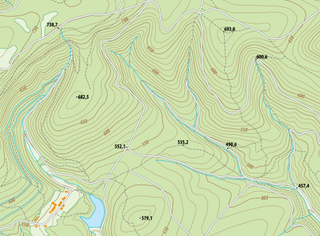
Topographic surveying allows obtaining highly accurate plans of land plots, including the actual data on their shape, contours, terrain relief, as well as all geographical and geometric elements and objects present on them. It serves as a fundamental source material for the development of master plans of the territory, construction projects, engineering design, and other purposes. Additionally, topographic survey data can be used as a basis for creating digital terrain models.
\9845769-57
We provide data for various types and levels of topographic and geodetic works in scales of 1:500, 1:1000, 1:2000, and 1:5000 to solve the following tasks:
[ 01 ]\
[ 02 ]\
[ 03 ]\
[ 04 ]\
[ 05 ]\
THE TECHNOLOGY WE USE TO ACCOMPLISH THIS
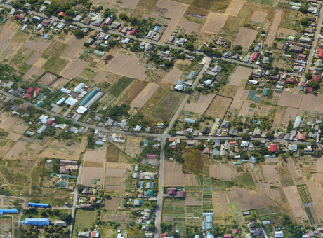
For data collection, we use our own developed UAV called "Skif" - a fixed-wing type of drone. In one shift, a single aircraft can cover an area of up to 1,000 hectares, and with a modern navigation system and a 61 MP camera, we can obtain images with a resolution of up to 1 cm per pixel.
Learn more
\9845769-57
We provide services as DaaS - Drone-as-a-Service. This allows you to avoid purchasing non-specialized aviation equipment and simply enter into an aerial monitoring contract and wait for the ready data within a few days.
This working format increases the speed and quality of work execution and enables large-scale research to be conducted on any area within tight deadlines.


WORK PROCESS
-
[ 1 - 4 ]
Preparation of technical specifications and work execution plan, collection and analysis of necessary information, study of documentation
-
[ 2 - 4 ]
Obtaining permission to perform the work, deployment of the flight crew, reconnaissance of the area, and aerial photography
-
[ 3 - 4 ]
Systematization and analysis of the collected data, preparation of topographic materials based on them
-
[ 4 - 4 ]
Compilation of a summary report and provision in a convenient format for the client
WHY CHOOSE CULVER AEROSPACE AS A PARTNER FOR YOUR BUSINESS?
[ 01 ]\
[ 02 ]\
[ 03 ]\
[ 04 ]\
[ 05 ]\
[ 06 ]\
[ 07 ]\