The consequence of the decentralization reform in Ukraine was the allocation of a new unit of administrative-territorial structure – territorial community (hereinafter – TC). This necessitated the introduction of appropriate changes to the legislative framework for the rational use of land resources of the newly created communities. On July 24, 2021, the Law of Ukraine No. 711-IX on Land Use Planning came into force, which introduced comprehensive planning for the development of UTC territories.
A comprehensive plan for the spatial development of a community's territory is both urban planning documentation at the local level and land management documentation developed to ensure sustainable development, financial stability, and prosperity.
In simple words, it is a document that includes plans for the prospective use of the entire territory of the community based on the analysis of its resources and provides the ATC with effective mechanisms and tools for managing its development. The comprehensive plan ensures coordinated decision-making on the holistic spatial development of all ATC settlements as a single system and addresses issues related to ensuring an adequate standard of living for residents, creating favorable conditions for local business and attracting investment, and developing social, transport, and engineering infrastructure throughout the community.
Thus, the comprehensive plan of the spatial development of the territorial community territory includes the following thematic sections:
- spatial planning organization of the territory;
- land management and land use;
- landscape planning;
- restrictions on land use;
- functional zoning of the territory of the territorial community;
- development of territories and economic activity;
- public services;
- transport mobility and infrastructure;
- engineering support of the territory, pipeline transport, and telecommunications;
- land protection, engineering preparation, and landscaping.
Comprehensive spatial development plans should provide 1469 territorial communities of Ukraine with the opportunity to identify problems, threats, and priorities of their development, as well as to balance the interests of the authorities, businesses, and the community itself. It is expected that the development of these documents will be able to stop the chaotic development in the regions and establish a clear purpose for each land plot belonging to the ATCs. Here is how aerial photography data collected by UAVs help to ensure sustainable development and effective land bank management for communities.
Why should territorial communities digitize and visualize their lands as part of the development of comprehensive spatial development plans?
Creating effective mechanisms for digitization and visualization of AH lands is an opportunity to increase the territorial community's budget revenues and ensure its sustainable development. One of the first steps in the implementation of a comprehensive spatial development plan is an audit of all available resources to ensure the rational use of land, forests and forest lands, water resources, etc.
Accounting of all community's territories is a necessary step to ensure their prospective use and development. The efficiency of hromada's resource management mechanisms, the formation of its positive image and investment attractiveness, as well as economic growth, an increase of local budget revenues, the well-being of residents, and the improvement of territories, etc. will depend on how well the boundaries of land plots, their designated purpose, ownership, and use rights are determined.
Since the comprehensive plan of the spatial development of the territory of the territorial community is both urban planning documentation and land management documentation, its development provides an opportunity not only to avoid conflicts between urban planners and land managers and to use land plots more rationally but also to change their intended purpose by the perspective plan for the development of the community. Thus, this will allow ATCs to establish communication, achieve openness and transparency in the development of their territories, establish a clear understanding of restrictions on land use, their value and normative monetary valuation of land, effectively identify plots for multi-story buildings, development of industrial and communal infrastructure, etc.
Digitization and visualization of the land bank of territorial communities as part of the development of comprehensive plans for the spatial development of territories is the key to transforming the vision of the future of the ATC into a tool for managing its development. To make the management of community property more efficient and rational, and the spheres of land management and urban planning open and transparent, local governments can use aerial photography data obtained using unmanned aerial vehicles.
How the data collected by UAVs help ATCs to ensure sustainable development and effective land bank management
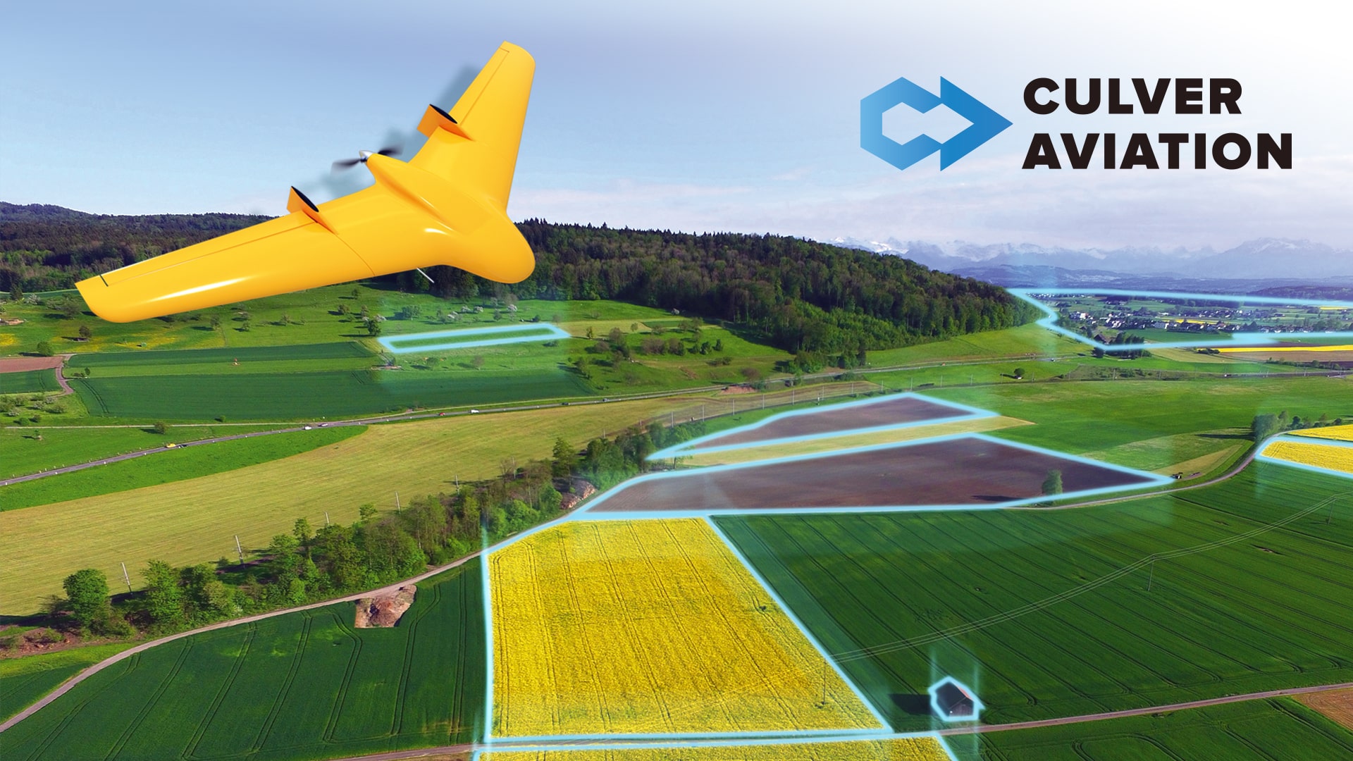
Aerial photography is one of the most effective and efficient methods of collecting spatial information from the Earth's surface. Digital data obtained with the help of UAVs become the basis for creating topographic plans and maps, urban planning documentation, as well as digital terrain and relief models. UAV aerial photography allows us to cover large areas and obtain images of high accuracy and quality to create detailed orthophotomaps of the earth's surface.
Thus, the UAV "Skif" of Culver Aviation's development can fly over the territory of up to 1,500 hectares in one shift, and a modern navigation system and a camera with a 61 MP matrix allow to obtain accuracy at a scale of 1 cm of land per 1 pixel in digital maps. The data obtained with the help of aerial photography make it possible to quickly obtain an accurate map of the terrain and settlements in high resolution and comprehensive information about the state of objects and the dynamics of their changes.
Thus, one of the components of the development of comprehensive plans for the spatial development of the TG territories is the creation of topographic plans of several scales:
- 1:10000 – for the entire territory of the community with the reflection of individual regime-forming objects;
- 1:2000 – for the territory of the administrative center of the ATC and individual settlements;
- 1:500 – for detailed plans of individual territories, including land plots.
An important advantage of using drones to obtain topographic data is their ability to collect information even in hard-to-reach places when traditional measurement methods do not work or are too difficult to implement. The availability of UAVs and the efficiency of obtaining data with their help will allow the ATC management to respond to all changes promptly and not only have up-to-date data on their territories, but also a modern, convenient and informative digital tool for community management.
Also, the information obtained can serve as the basis for creating three-dimensional models to form a real picture of the area and make informed management decisions on territory management, design of communications, and planning of infrastructure development in the region. Thus, the creation of digital elevation models allows us to analyze the structure of land use and optimize the functional zoning of territories taking into account their landscape features.
The spatial data obtained with the help of UAVs are indispensable for conducting an inventory of land plots, assessing the fullness of the land bank, and creating comprehensive plans for the spatial development of territorial communities on their basis.
Possibilities of using aerial photography data with the help of drones for territorial communities:
- establishing the boundaries of the territorial community and settlements;
- inventory of land plots and objects and updating of normative monetary valuation, which is the basis for taxation;
- regulation of land boundaries, monitoring of rights to real estate, identification of their owners and land users;
- visualization of all community property in the form of a digital or paper report;
- planning of urban development and infrastructure development;
- topographic survey of the area for the design of communications, construction, and reconstruction of facilities;
- management of the land bank and community facilities and their lease to users on more favorable terms for the community;
- development of general plans for settlements;
- planning of spatial development of the territorial community, formation of its positive image, and investment attractiveness;
- aerial photography of destruction and damage caused by the war and the consequences of fires, man-made accidents, and natural disasters.
The use of UAVs allows the TG to obtain up-to-date data on the land bank* and increase the efficiency of land management based on their analysis and order. This allows increasing revenues to local budgets by identifying unaccounted real estate and increasing the normative monetary value of land, attracting investment and ensuring sustainable community development.
Why Culver Aviation
We specialize in providing aerial photography of the earth's surface and monitoring high-rise objects using drones of our design and production.
1. A full cycle of aerial photography services - from collecting information using UAVs to digitization, analysis, and preparation of a report in the format specified by the customer.
2. We carry out pilot projects and large-scale studies in any area in a short time. If the equipment goes for maintenance, it always has a replacement.
3. The cameras on our drones take images of the earth's surface ten times better than the satellite, which allows us to create orthophotomaps with an accuracy of 1 cm per pixel.
4. Engineers and designers in our R&D department are constantly working on improving our drones and creating new models. Also, our UAVs can be equipped with additional functionality according to the needs of customers.
5. Our specialists have extensive experience in aerial photography and are constantly improving their drone control skills.
6. At the request of the customer, we can provide data in the format of three-dimensional models, which quickly form a real picture of the state of objects, including historical and cultural monuments.
7. Having our GIS department allows us to quickly process UAV survey data and create orthophotomaps and 3D models of high accuracy and quality based on it.
Do you want to know how aerial monitoring can help to solve the problems of your community? Please call 0 800 351 709.
*subject to open access to the State Land Cadastre and the State Register of Real Property Rights