Multispectral imagery allows us to effectively monitor seedlings' condition, record all crop development changes, and see all the nuances of crop development, inaccessible to human vision. Analysis of information obtained through multispectral mapping helps farmers to plan fertilization and plant protection products in time, save money and increase yields.
The Aerial Monitoring UAV Network Menatir, designed by Culver Aviation specialists, allows conducting continuous and automated monitoring of crops without going to the field, with a response time of 3 minutes. Here is how it works.
How multispectral photography helps to solve agricultural problems
A camera with a multispectral sensor is installed on the drone to collect data on soil conditions and crop health. It records the frequency and wavelengths reflected by plants and other surfaces in the green, red, and infrared spectrums invisible to the human eye.
The data obtained using multispectral imaging allow us to determine:
- dynamics of plant vegetation;
- chlorophyll content;
- outbreaks of fungal diseases;
- damage due to frost;
- heterogeneity of seedlings, etc.

Vegetation indices
Their vegetation indices can be determined by measuring the reflected light of plants. The most common of them are NDVI and NDRE.
NDVI (Normalized Difference Vegetation Index) is a quantitative index, which is influenced by a combination of different factors, in particular: the photosynthetic activity of plants, total vegetation cover, biomass, moisture of plants and soils, etc.
NDVI maps are created based on the data obtained using multispectral imaging, which allows for comparing the condition of seedlings at different stages of their development and in specific areas. Fast processing of such data will help farmers effectively manage their farms and save time and money through the differentiated application of fertilizers and plant protection products.
The NDRE index (Normalized Difference Red Edge Index) is an indicator that allows you to detect diseases in plants by recording all the changes that occur during their development.
Also, the use of the NDRE index makes it possible to control the activity of photosynthesis of plants by determining their level of chlorophyll (green pigment with which they capture the energy of sunlight), which in turn allows you to optimize the timing of the harvest.
Monitoring data of NDVI and NDRE indices provide farmers with valuable information for the timely detection of problems and for making informed management decisions based on their analysis.
MENATIR — "assistant in the air" for agribusiness
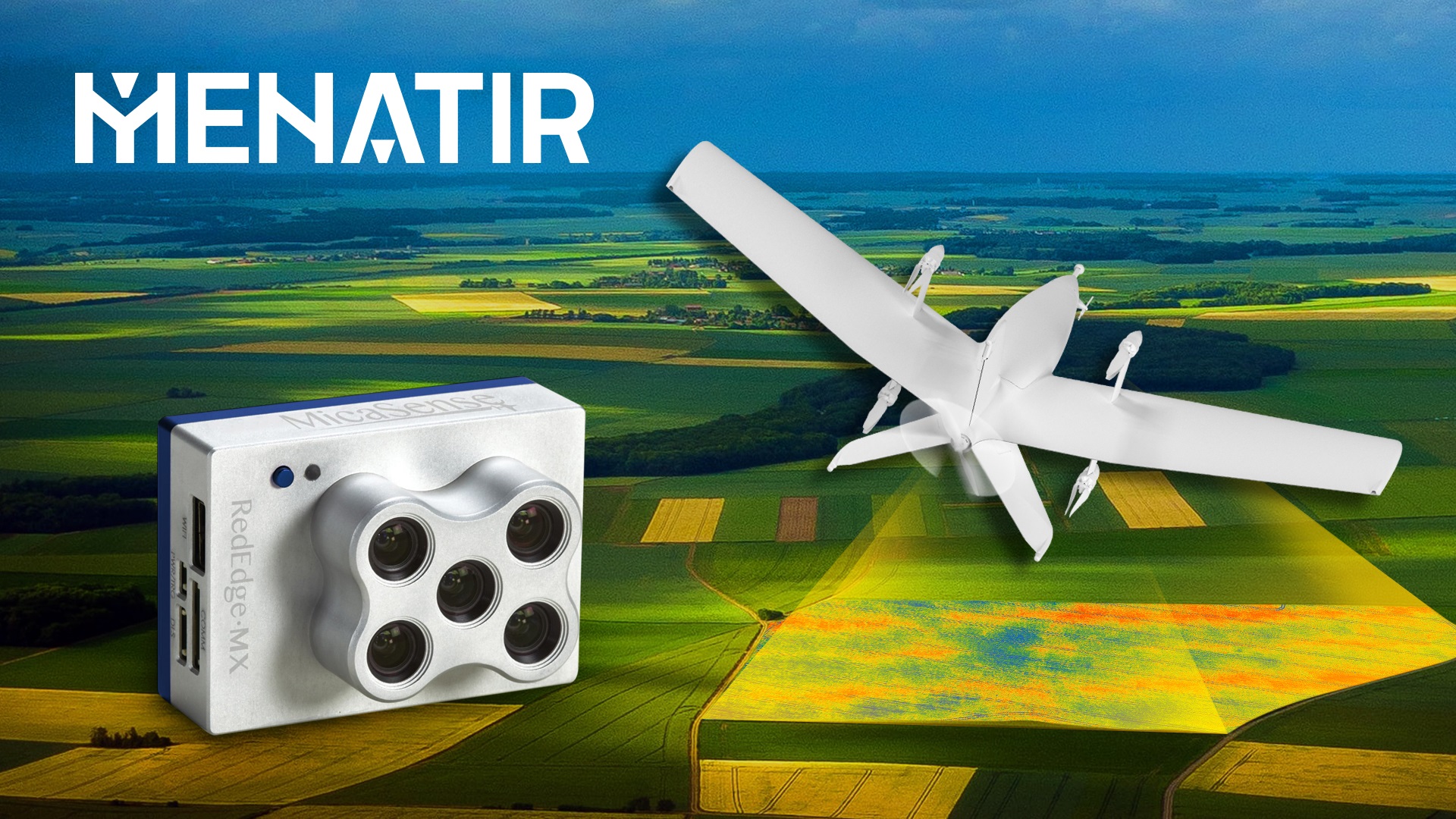
One of the payloads of the Menatir UAV aerial monitoring network is a five-band multispectral camera with panchromatic imaging mode, designed to monitor agricultural land, green areas, and water bodies.
Panchromatic optical imaging is carried out in the entire visible range at once, and panchromatic images have a higher spatial resolution, which allows them to be used for solving topographic problems and clarifying the boundaries of objects.
Depending on the shooting altitude, the camera installed on the aircraft allows one to obtain images with a resolution of up to 4 cm/pixel. It is also equipped with a light sensor for image correction. Thanks to this, MENATIR provides the advanced multispectral mapping of crops, orchards, green areas, and water bodies.
The Menatir network allows for fully automated and continuous observation of the earth's surface 24/7. MENATIR provides agricultural enterprises with reliable data to determine yield potential, water stress, irrigation efficiency, location of drainage lines, weeds and diseases, fungal diseases, etc. in real-time according to a planned schedule or on request.
A network of 5 Menatir base stations with 6 UAVs each will allow the collecting of data from the territory of up to 45,000 hectares per day. Unlike satellites, drones can take images of the earth's surface even in cloudy weather and exactly when the farm needs it. Cameras with high-resolution matrices make it possible to capture the smallest details in the development of crops.
The data obtained by multispectral mapping with MENATIR allows agricultural producers to:
- identify problem areas at early stages from the air without damaging crops
- detect pests, diseases, and weeds, as well as nutrient deficiencies, and optimize the use of plant protection products
- analyze seedlings and estimate yields
- increase the efficiency of agricultural machinery based on the analysis of problem areas
Also, with the help of the system's drones equipped with digital cameras with high-resolution matrices, farmers will be able to receive orthophotomaps of fields and agricultural land, determine the area of fields and crops, the exact contours and relief of fields, and with the help of a daylight camera - to inspect the property of the enterprise and monitor it in real-time.
Combining the functionality of drones with different payloads in one system will allow farmers to identify all problem areas in time and successfully deal with challenges throughout the growing season.
Only one operator is needed to manage the Menatir system, regardless of the number of base stations. To carry out continuous automatic monitoring of their crops and agricultural land, the owners of agricultural enterprises only need to define the research area, the system will do the rest - calculate the height and pattern of the flight mission, the time of launching the camera, etc. The drones of the network will take off, complete the task and return to the station in fully automatic mode.
What else can the Menatir system be used for
The information that the Menatir UAV base station network receives from the Earth's surface is a source of reliable data not only for agricultural enterprises but also for several services - fire, road, environmental, municipal, infrastructure, and others.
For example, with the help of the Menatir system, in real-time, according to a planned schedule or on request, you can carry out:
- video surveillance of any objects in real-time;
- aerial photography in HD quality to create orthophotomaps of the area;
- air quality monitoring;
- prevent landscape fires, etc.
How MENATIR allows providing continuous monitoring and analysis of air quality in atomic mode, we told here. To learn more about the capabilities of other types of system payloads, follow our news.
Menatir performs research in real-time and allows you to minimize the impact of factors and conditions that precede the launch of a conventional drone. Automated and continuous agro-monitoring with the help of the Menatir system will free the owners of agricultural enterprises from the need to solve organizational issues related to the search and control of contractors, departure of the flight team to the field, etc. This makes it a real "assistant in the air" for making informed management decisions by agricultural enterprises. More information about the capabilities of the Menatir system is available here.