Agromonitoring is an important component of proper field work planning and efficient resource management. To optimize farming, monitor the situation inside the field and identify problem areas in time, unmanned aerial vehicles come to help farmers. They allow to see things that are unavailable during a regular inspection. We will tell you how it works on the example of one of the implemented projects of Culver Aviation.
Eyes in the sky: why farmers should take photos of their land from the air
Identification of crop heterogeneity on the field is necessary for making informed management decisions. Did you know that up to 8% of yield per hectare can be lost due to problem areas?
By examining the condition of crops at different stages of their development and identifying problem areas, the farmer gets the opportunity to optimize the routes of agricultural machinery, introduce differentiated fertilization and crop treatment and other agrotechnical operations.
Orthophotomaps created on the basis of images received from the drone allow you to determine the contours and area of the plots with centimeter accuracy, to investigate the condition of crops and the situation inside the field, which is impossible with a regular inspection during the round. This is the only way to identify all problem areas on the field (shedding, uneven germination, wet or trampled places, etc.) and take appropriate measures to eliminate them. For example, to plan the effective cultivation of different parts of one field, to choose the optimal technology of fertilizers and plant protection products to equalize the yield in different areas, etc. In the future, this data can also be used to implement precision farming systems.
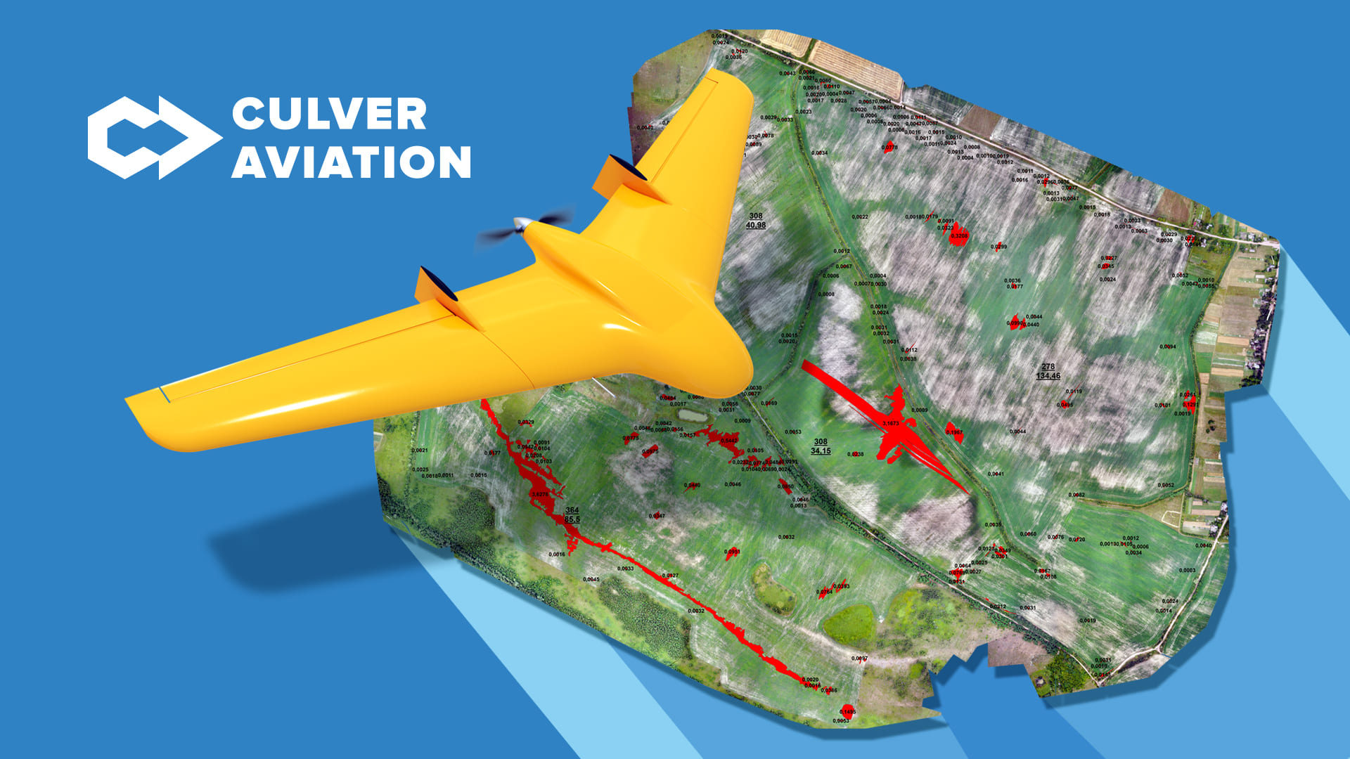
This is how the project on visual assessment of crops and identification of problem areas, implemented by Culver Aviation specialists with the help of UAVs of its own production “Skif”, looks like:

The data obtained from aerial photography and analyzed allowed us to determine that for a crop area of 295 hectares, the problem areas on the field amounted to almost 11 hectares (highlighted in red on the image). This is 3.68% of the total area! In fact, these are places that, due to the influence of various factors, have not been sown for a long time. One can only imagine how much harvest was lost by the farm during this period of time.
Also on the orthophotomap, areas with uneven germination are shown in gray. Inaccessible by normal inspection due to the distance from the road, they would also lead to significant crop losses. However, their detection will allow the farmer to take appropriate measures in time and prevent this.
What else can be seen from the air?
Multispectral imaging allows you to effectively monitor the condition of seedlings, plan fertilization and plant protection products and see all the nuances of crop development that are inaccessible to human vision.
How it works
Objects with different surface characteristics reflect or absorb solar radiation differently. To collect data on the condition and health of crops, a camera with a multispectral sensor is installed on the drone, which captures data with a specific frequency and wavelength. Vegetation indices determined by measuring the reflected light of plants allow comparing the condition of seedlings at different stages of their development and in specific areas.

In particular, they can be used to determine
- dynamics of plant vegetation;
- chlorophyll content;
- disease outbreaks;
- damage due to frost;
- heterogeneity of seedlings, etc.
With the help of multispectral imagery data, farmers will be able to identify problems in time and make informed management decisions. Their analysis allows you to record all changes in the development of crops and save time and money through the introduction of differentiated application of fertilizers and plant protection products.
Why Culver Aviation?
Culver Aviation provides agro-monitoring services as a DaaS — Drone-as-a-Service. This allows farmers not to buy non-core aircraft for them, but simply conclude an agreement on aerial monitoring and receive ready-made data in a matter of days.
In our work we use UAV “Skif" of our own design, equipped with a camera with a resolution of 61 MP. Also, a camera with a multispectral sensor can be installed on “Skif".
Find out how orthophotomapping and multispectral photography can help your company by calling 0 800 351 709.