Digitization of the land bank of territorial communities is the key to successful planning of their development. To make the management of community property more efficient, UAVs come to the aid of local governments.
Along with land management, the leadership of village, town and city councils are tasked with ensuring the functioning and maintenance of cemeteries. They should not only carry out the improvement of cemeteries and adjacent territories, but also monitor the condition and availability of free territory for new burials, and in case it is physically not enough - to ensure the commissioning of a new place for burial and commemoration of the dead.
The territory for the arrangement of a new cemetery must meet a whole list of conditions regulated by law. This includes compliance with the requirements for location, compliance with sanitary and hygienic standards and even predicting the impact of geological processes. There are also urban planning conditions and restrictions for cemeteries.
Drones have long established themselves as an unsurpassed method of data collection. Their use makes it possible to determine the boundaries of areas that are often inaccessible from the ground due to dense vegetation, to investigate the condition of territories from the air, to identify threats from natural and urban factors. Here is how drones are used to explore existing cemeteries and arrange new ones.
What are the requirements for the arrangement of cemeteries provided by law
The basic requirements for the arrangement and maintenance of cemeteries in settlements are regulated by the Law of Ukraine "On Burial and Funeral Business". According to Article 23 of the Law, the planning and arrangement of the territory of burial places should be carried out "in accordance with the general plans of development and with the obligatory observance of urban planning, environmental and sanitary and hygienic requirements".
Thus, the legislation stipulates that cemeteries should be located in the suburban area of urban settlements and near villages. The sanitary protection zone to residential and public buildings, recreation areas, as well as collective gardens should not be less than 300 meters.
In addition to the requirements for location on the ground, the site allocated for the cemetery should not be affected by such geological phenomena as landslides and collapses, flooded or flooded by melt, rain and flood waters, and the soils on its territory should be easily aerated. If there is a slope, the plot is suitable for use as a cemetery only if it is located in the opposite direction from the settlement and open water bodies, if they are used for household needs.
Also, cemeteries should be fenced around the perimeter and have well-maintained access roads, provided with transport links to the city.
How UAVs help to ensure the arrangement of cemeteries
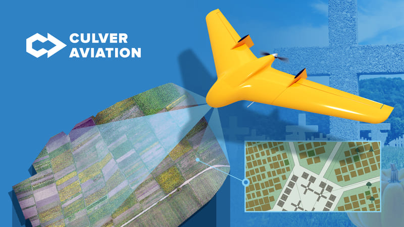
First of all, the use of UAVs allows you to create orthophotomaps of existing cemeteries to assess the possibilities of their expansion, study the territory and landscape around, the impact of natural and urban factors, etc. Drones provide an opportunity to obtain information about hard-to-reach areas and illegal burials that cannot be recorded from the ground. In addition, UAVs can be used to accurately measure the territory and all objects located on it, which can be used to calculate buffer zones.
Orthophotomaps are also indispensable in the design and arrangement of new cemeteries. Photographs of the area obtained from the UAV allow to comprehensively examine the site from the air and determine its compliance with the requirements provided by law. Also, based on aerial photography data, the exact contours and area of the site are determined.
Such a project was implemented by the Culver Aviation team for the Tlumatch city community in the Ivano-Frankivsk region. Based on the results of the research and overflight of the territory at an altitude of 200 m, orthophotomaps with an accuracy of 2.1 cm/pixel of the existing cemetery and the area allocated for the construction of a new one were generated. The company's own UAV "Scythian" was used for data collection.

Depending on the requirements of customers and the nature of the surveyed areas, the data collected by UAVs can be provided in other formats. For example, in the form of a digital terrain or surface model - to display information about the height and features of the landscape. Also, based on the information received from the air, a point cloud or 3D model of the site and objects on it can be created, which is especially useful for cultural heritage research projects.
Culver Aviation provides a full range of services based on aerial photography and monitoring of the earth's surface using UAVs on the Drone-as-a-Service model. You can order any of the above services from us. For all questions, please contact us by phone 0 800 351 709.