Today there are almost no industries that do not use UAVs in their work. With their help, they obtain accurate data about objects, assess the consequences of natural and natural disasters, determine the condition of crops and even develop plans for search and rescue operations.
However, despite their name, unmanned aerial vehicles require careful support from operators, which means additional time, money, and the influence of the human factor on aerial monitoring.
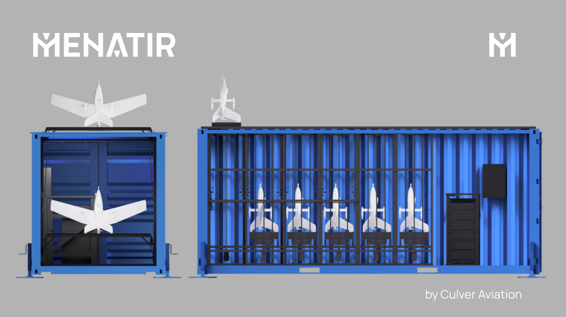
To minimize them, Culver Aviation has designed and developed an automated system for monitoring the earth's surface using UAVs — Menatir. This is a network of base stations in the form of containers with unmanned aerial vehicles inside. The aircraft are launched automatically remotely from a flight control center or according to pre-programmed tasks, and only one operator is needed to manage the entire system.
Menatir has become a response to the demand of industries that need to quickly and thoroughly monitor the earth's surface with a subsequent operational analysis of the data obtained. In the article for ITC.ua, we told about the uniqueness of our development and how Menatir helps companies and government agencies make optimal management decisions.
Air monitoring with the help of drones has not surprised anyone for many years. More precisely, it was not surprising until September 2022. It was then that at the international exhibition Commercial UAV Expo 2022 in Las Vegas, Culver Aviation presented its new development — an innovative automated air monitoring system using UAVs — Menatir.
Drones cannot do without pilots
However, drones, despite the name, require the careful support of the pilot operator. It is the pilot who has to plan the mission, choose the best weather window, go to the field, set the route and survey parameters, launch the drone, control the flight, and pick up the UAV after landing.
Being an experienced operator means hundreds of flight hours, training costs, and salary. But only with him, UAV can develop its potential to the maximum. The more drones are taken off at the same time, the more operators are needed for them.
You can intensively train pilots and simultaneously develop the technology of UAVs themselves. Or you can try to remove the human factor from all possible links of remote monitoring. This is the path taken by Culver Aviation, which has been developing its drones and providing services on their basis since 2014.
To teach UAVs full independence
"We aimed to create a system that would speed up the implementation of the monitoring task and perform missions without the participation of an operator," says CTO of Culver Aviation Yevhen Shamalo, "We also wanted to reduce the impact of unpredictable factors, such as weather, a broken car or illness of a flight team member, which can delay the mission for days or weeks.
So Culver Aviation created the Menatir system. This is a network of base stations in the form of containers with unmanned aerial vehicles inside. The aircraft are launched automatically remotely from the flight control center at the command of the operator or by pre-programmed tasks.
By the way, the Elvish menatir is translated as "care of the territory", the company says. This is a reference to the fact that in mythological universes elves made complex and most unusual devices.
Despite the simple description, the engineers had to build a single ecosystem in which all components — drones, base stations, navigation systems, and software - work as a well-coordinated mechanism.
For Menatir, Culver Aviation engineers have developed unique "tailsitter" drones. When the command to take off is received, the aircraft with the help of a manipulator rises to the launch pad of the container, vertically takes off to the required height, and switches to horizontal flight mode to complete the mission. It lands in the reverse order: the drone flies horizontally to the station, switches to vertical flight mode, and lands in the container.

The system independently launches drones and controls their flight until landing. It takes only three minutes from the moment of receiving the command to the take-off of the aircraft. During this time, the system calculates the route and duration of the flight without human intervention.
Non-standard standard container
From the outside, the network base station is a typical 20-foot shipping container. But the most interesting thing is hidden inside.
The container contains up to six drones. Inside, they are charged, pre-processed, and transmit the collected data. Special equipment delivers the aircraft to the starting position at the top of the container, from where the launch takes place.
Before each flight, the system automatically analyzes meteorological conditions. Information about the weather comes from special services and the regular weather station. In case of adverse weather conditions, the flight is canceled or postponed. If the weather changes during the flight, the aircraft terminates the mission and returns to the base.

All stations are equipped with RTK receivers that provide centimeter accuracy of navigation system positioning during the flight. With their help, you can create your own RTK network or connect to an existing one.
Stations need to be connected to the power grid but can work in conditions of power outages. Each base is equipped with an uninterruptible power supply and a diesel generator. Therefore, the flight mission will be performed in any situation with a power supply.
Control system
Menatir is a complex system that requires integrated approaches in engineering and IT. That is why the company has developed a multi-level hardware and software solution that ensures the life of the entire system.
The "brain" of the aircraft is the flight controller. It is built based on internationally recognized standards and high-performance components. To ensure reliability, its software undergoes many different tests — from simulation to flight tests.
The entire system is controlled by the flight control center. Its software selects the optimal UAV in terms of location and configuration at the appropriate base station and automatically generates an application for the use of airspace. During the mission, the control center operator monitors the UAV flight and corrects it if necessary.
The complex interaction of the ground station, UAV, and control center is achieved through proprietary engineering solutions and software using artificial intelligence.
One network — different tasks
Menatir can provide a variety of analytical information — from air pollution levels to the condition of industrial facilities. All this is because drones can carry six different types of useful equipment:
- a video camera on a three-axis suspension — for real-time video monitoring;
- a video camera with a thermal imager — for monitoring in the dark, in difficult weather conditions, and for fire prevention;
- high-resolution digital camera — for mapping, creating orthophotomaps, and 3D models of terrain and objects;
- multispectral camera — for monitoring the condition of crops, green areas, and water bodies, detecting soil erosion;
- eco-sensor — for air quality monitoring;
- the custom payload on demand — subject to compliance with weight and size parameters.

Depending on the task, the base station can accommodate aircraft with the same or different equipment.
"We have counted more than 30 areas that can be covered by one of our solutions," says Culver Aviation CEO Oleksandr Danylenko, "The flexibility and diversity of Menatir equipment allow businesses and government agencies to use it — from small farms to fire, road, environmental, municipal, infrastructure and other services.
More containers — more opportunities
The range of one station is 45 km: that's how far an aircraft can fly on a single charge and return. But the network principle makes Menatir coverage conditionally unlimited. For example, a system of five containers will allow monitoring of an area of about 50 thousand hectares.
The advantage of this approach is that the network can provide continuous monitoring of the selected area, as well as overlapping zones and "alternate airfields".
For example, if there are unfavorable weather conditions in the area of one container, a drone from another container where the weather is better can fly to the task. Drones will move freely between containers to perform tasks more efficiently. And in case of an emergency, the drone will be able to land at the nearest base.
If the system has several aircraft with the same equipment, it can perform similar tasks simultaneously at different sites. However, regardless of the number of base stations, Menatir requires only one specialist who can operate the system from anywhere in the world.
Menatir helps to make management decisions
The system from Culver Aviation has become a response to the demand of industries that need to quickly and thoroughly monitor the earth's surface with further analysis of the data obtained.
For example, in agriculture with Menatir you can keep records of the land bank and monitor the condition of crops, and in the industry — to control the territory, the state of objects, and harmful emissions. Also with the help of Menatir it is possible to carry out measurements in quarries, predict the risks of accidents and other critical situations, to monitor the condition of power grids, construction, and long objects such as roads, power lines, and pipelines.
At the national level, Menatir can be used for land inventory, cadastral surveying, traffic monitoring, analysis of road or railway infrastructure, as well as monitoring water levels in reservoirs and air quality.
Automatic round-the-clock fast analytics allows businesses and governments to make the most appropriate decisions. In manual mode or with the use of satellite technologies it is impossible to achieve such efficiency and accuracy as with Menatir.
"Menatir provides information from the air," sums up Yevhen Shamalo, "Such analytics opens up new opportunities and makes our life more comfortable and safe, and the environment more predictable. This is the priority of modern technologies, and not only unmanned ones".